Elevation
6,402.04 ft
full pool* 6,410 ft · ramp 6,373 ft
Storage
58,580 AF
full pool* 76,200 AF
% of full pool
77%
as of 2026-08-01 (PT)
*Full pool = the reservoir’s maximum normal operating level (76,200 acre-feet at elevation 6,410 ft); water above this spills. Data: CDEC station LON (Loon Lake, SMUD) · daily storage & elevation. Disclaimer: Values are estimates from CDEC/SMUD and may vary significantly from actual conditions. Neither SMUD nor PG&E assumes responsibility for accuracy. Not for navigation or safety decisions.
Loon Lake to Desolation Wilderness
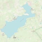
Topographic map showing Loon Lake, the Rubicon Trail east toward Lake Tahoe, and the Pacific Crest Trail through Desolation Wilderness. Tap the Loon Lake Chalet marker for directions and chalet info. Map data © OpenStreetMap contributors & SRTM · style © OpenTopoMap (CC-BY-SA).
As always alpine lakes in the Sierra Nevada are subject to extreme conditions as well as rapidly changing weather and conditions so it is important to keep on top of the latest weather conditions.
Loon Lake CA is at a 6,400 foot elevation and is subject to changing conditions such as:
- Temperature & Precipitation Changes
- Significant changes in wind direction and velocity
- Changing water levels
On this page we have compiled some key weather & data links for Loon Lake as well as nearby weather stations to help you prepare your trip.